Calgary's Top 7 Destructive Hailstorms: An Examination of Their Meteorological Environments
Kyle Brittain
2/19/2026
Part one: Introduction
Canada's hail capital
Whether it smashes windows, destroys roofs and siding, dents vehicles, or shreds crops, hail is by far the costliest thunderstorm hazard. In the hail-prone regions of central and southern Alberta, catastrophic hail events are becoming a nearly annual occurrence.

Figure 1: Severe damage to the exterior of a home in northeast Calgary following the $1.3B 13 June 2020 hail event. Windows were shattered and vinyl siding shredded on exposed aspects of countless homes.
Since 2020 alone, hail has caused an estimated $6 billion in insured damage across Alberta. Two of the most destructive storms struck Calgary, with combined insured losses exceeding $4.5 billion between 13 June 2020 and 5 August 2024.
The 2024 storm alone caused $3.25 billion in insured losses, making it the second costliest disaster in Canadian history and one of the most expensive hailstorms ever recorded worldwide. Events like these have firmly established Calgary’s reputation as Canada’s hail capital.


Why hail events are getting worse in Calgary
Calgary is a sprawling city that continues to rapidly grow, and that growth plays a major role in why hail damage is becoming more severe. One of the most important factors is the “expanding bullseye effect”. As suburban communities spread outward, there are simply more homes, vehicles, and other values exposed to be hit by hailstorms.
Figure 2: Calgary's 7 costliest hailstorms.

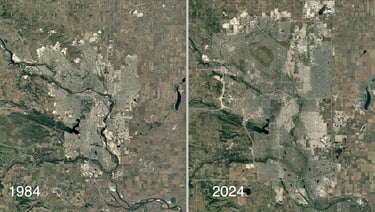
Figure 3: Satellite imagery of Calgary in 1984 and 2024.
Since 1984, Calgary’s land area has expanded by nearly 50%, reaching its current footprint of about 825 square kilometres. Over the same period, the city’s population more than doubled to nearly 1.5 million residents.
Much of this growth has occurred toward the north, an area where destructive hailstorms are more common. Of the seven costliest hail events in the Calgary region, six affected the city’s northern two quadrants or areas immediately to the north.


Figure 4: The approximate tracks of Calgary's 7 costliest hailstorms, based on radar imagery and storm reports.
If the extremely costly hailstorms of 2020 and 2024 had occurred in 1984, they would have largely passed over open farmland, causing far less damage to homes and vehicles. As Calgary continues to expand, the city becomes a bigger target for severe hailstorms.
Why the northern half of the Calgary region experiences more frequent damaging hail warrants further study. One possible explanation involves how low-level winds interact with local terrain, making thunderstorm development more likely in certain areas along the foothills. Terrain features such as the Cochrane ridge, which follows the northern edge of the Bow River valley and ends at Nose Hill, may also help guide storms into the northern half of the city.
In any case, a common, northwest-to-southeast storm track exists through northern and northeastern areas of the Calgary region. Here, numerous cases of long-track, destructive hailstorms over cropland have left hail swaths visible on satellite imagery, showing that hail does not necessarily have to be large to inflict severe damage.
As for how climate change may be influencing hail risk, research summarized by the IPCC suggests that long-term trends in severe thunderstorms remain uncertain. One modeling study found that hailstorms in North America may become less frequent overall, but with larger and more damaging hailstones. For now, however, urban expansion appears to be the dominant driver behind Calgary’s rising hail losses - especially if broader damage-mitigation measures are not adopted.
Insurance is getting costlier
The growing impact of catastrophic hailstorms is placing increasing strain on insurance providers. This has sparked wider discussions about community resilience, as insurance premiums continue to rise for consumers.
Alberta’s auto insurance industry has been particularly affected, since vehicle damage often accounts for at least half of all insurance claims during major hailstorms.


Figure 5: Severe damage to vehicles in northeast Calgary following the June 13, 2020 event.
The aim of this study
One way to reduce hail damage at the community level is through improved early warnings, which give people more time to prepare - such as moving vehicles under cover when possible.
This informal study examines the meteorological environments associated with Calgary’s seven most destructive hail events. By identifying common atmospheric patterns, this analysis aims to improve situational awareness, support more accurate forecasting, and enhance public messaging by providing greater lead time before damaging hail occurs.
Part two: Alberta hail environments
Why Alberta gets so much hail
Alberta experiences more frequent hailstorms than most other parts of Canada due to its unique geography. The Rocky Mountain foothills sit adjacent to vast agricultural areas that supply moisture to the atmosphere, while the summertime mid-latitude jet stream often passes overhead.

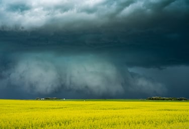
Figure 6: Ominous storm clouds serve as a striking backdrop to flowering canola fields over southern Alberta. Maturing wheat, barley, and canola are known to give off lots of moisture to the lower atmosphere through evapotranspiration when crops aren't water stressed. This period of crop maturation, usually through the month of July, often correlates with the peak of Alberta's severe weather season.
As healthy crops grow and mature, they release moisture into the air that can serve as fuel for thunderstorms. When low-level winds push this moist air westward toward the foothills, it is forced upward, enabling the development of tall clouds. If these clouds grow into a strong jet stream aloft - especially when an upper-level disturbance is approaching - more organized and long-lived severe thunderstorms can result.
As storms move eastward off the foothills and toward Alberta’s heavily populated QE2 Highway corridor, they frequently produce hail, sometimes reaching very large sizes. Hail is more likely to reach the ground in this region due to Alberta’s higher elevation and drier climate. A lower freezing level means hailstones have less time to melt, while dry air in the lower half of the atmosphere promotes evaporative cooling, keeping temperatures lower and further limiting melting.
Alberta has a rich history of thunderstorm research
Alberta’s frequent thunderstorms, wide-open landscapes, and excellent road network have made it an ideal location for hail and thunderstorm research.
Since the 1950s, numerous research programs have operated in the province. These include the Alberta Hail Studies (1957–1973) and the Alberta Hail Project (1974–1985), which culminated in the LIMEX-85 field experiment. Following a quieter period, research resumed with the UNSTABLE project in 2008. Most recently, the Northern Hail Project, launched in 2022 by the Canadian Severe Storms Laboratory, has renewed extensive research and field operations in Alberta.
Together, these efforts have greatly improved our understanding of severe thunderstorms and hail, contributing valuable knowledge to the broader scientific community.
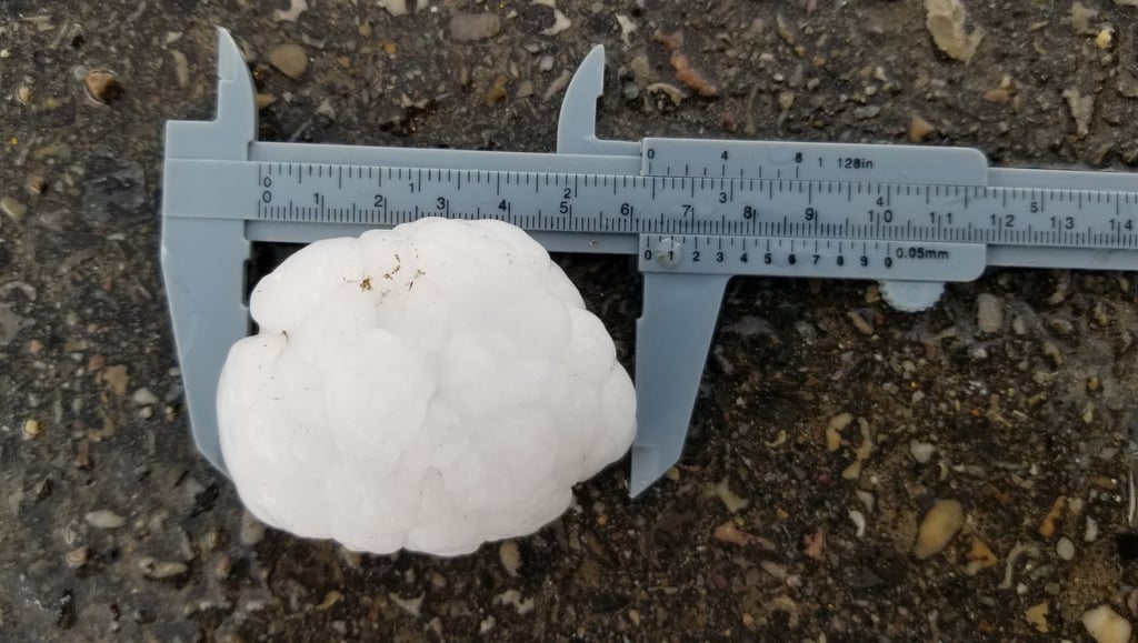

Figure 7: Measuring a large, recently-fallen hailstone in the foothills of central Alberta.
In addition, Canada’s only active hail suppression program has operated in Alberta since 1996 under Weather Modification, Inc. The program aims to reduce hail size by seeding storm clouds with silver iodide and runs from May through September. It covers an area from the foothills eastward to between High River and Ponoka, including the hail-prone cities of Calgary and Red Deer.
The classic conceptual model for severe storm development in Alberta
One major outcome of the Alberta Hail Project and LIMEX-85 was the development of a conceptual model describing how major severe thunderstorm outbreaks form in Alberta.
This model, developed by Smith and Yau, describes a two-stage atmospheric process:
Stage One
An upper-level ridge causes sinking air in the atmosphere, resulting in clear skies
Moisture builds near the surface, capped to deep convective development by warm air aloft
Winds are light, often with a westerly component that moves moisture away from the foothills
Stage Two
An upper-level trough approaches from the west, leading to cooling aloft and destabilization of the atmosphere
Strong solar heating, combined with cooling aloft, strengthens a local flow of moisture from the plains toward the foothills – known as the mountain-plain circulation
Large scale easterly flow pushes deeper moisture into the mountain-plain circulation, which is forced up the foothills, enabling organized thunderstorm development
For the most severe outbreaks to occur, the timing of the upper trough must be just right. Instability needs to build throughout the day and be released during peak heating. When strong easterly winds near the surface combine with southwesterly winds aloft, the resulting wind shear can support supercell thunderstorms, which are capable of producing large hail and other significant hazards.
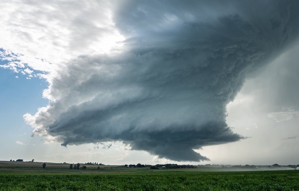
Figure 8: The striated appearance of a rotating updraft, as seen with this low-precipitation supercell near Strathmore, Alberta on 23 July 2020.
Part three: Hail science and forecasting
What science tells us about hail formation
Over the past few decades, extensive research has increased our understanding of everything from how hail forms to the improvement of hail forecasting techniques. The following section provides a brief overview of hail formation, drawing on key ideas summarized in a 2018 article by hail expert Julian Brimelow.
In simple terms, hail size is largely controlled by its residence time inside a deep, convective cloud. The longer it can stay suspended within a thunderstorm’s updraft, the larger the hail can grow.
Many hailstones are thought to begin their life in towering clouds that develop next to a thunderstorm’s main updraft. These clouds often contain soft, pellet-like ice particles called graupel, which can be swept into the storm’s stronger updraft. Once inside, these particles can act as embryos for growing hailstones.
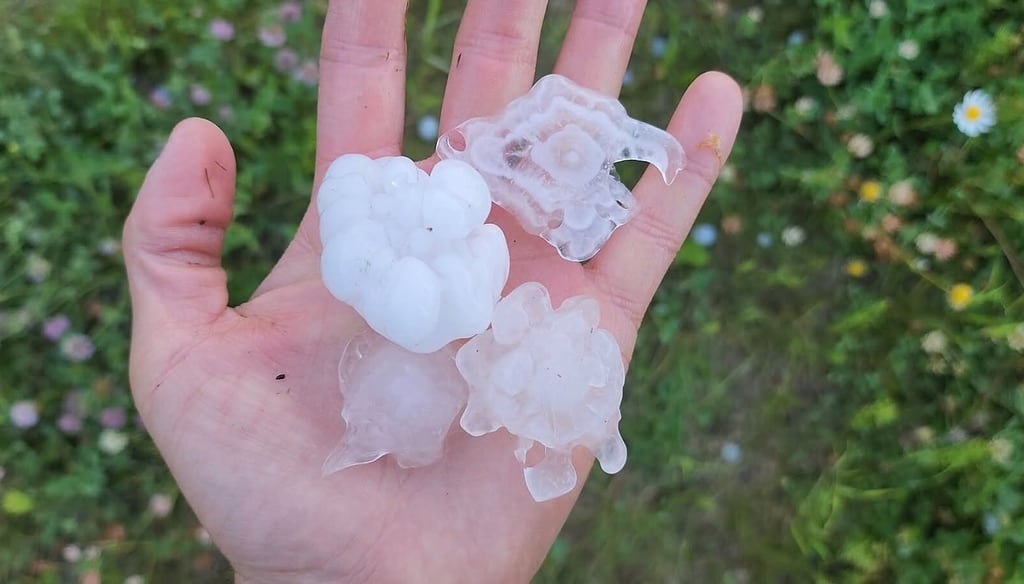
Figure 9: Hailstones come in many shapes and sizes. An embryo can be clearly seen in the centre of the top right stone, buried beneath different layers of growth.
The most efficient hail growth occurs within a specific region of the storm known as the hail growth zone (HGZ). This layer is typically found where temperatures range from about -10 to -30°C. In this zone, the updraft is filled with supercooled water droplets, which is liquid water that exists below freezing. When these droplets collide with a growing hailstone, they freeze instantly, allowing the hailstone to increase in size.
The paths that hailstones take through a thunderstorm can vary widely. Many are believed to make a single trip upward and then fall back to the ground. Others may travel more horizontally through the updraft, appearing to “hover” as the updraft speed closely matches the growing hailstone’s terminal velocity. The updraft rotation of supercell thunderstorms can further lengthen the hailstone’s trajectory, as it loops through the updraft before eventually falling out of the storm. The largest hailstones may remain suspended in the cloud for 20 minutes or more before reaching the ground.
To maximize hail growth, the storm’s updraft needs to be both wide and moderately strong. If the updraft is too strong, many growing hailstones can be ejected out of the storm before they have time to grow large. Wide updrafts are often supported by strong storm-relative inflow (storm-feeding winds that the storm "feels") and by the merging of nearby storm cells, which adds extra mass to the updraft. Strong vertical wind shear between the surface and mid-levels of the atmosphere can also help widen the updraft, creating a more favourable environment for large hail.


Figure 10: The hard, "crunchy" appearance of a strong updraft that consists primarily of supercooled, liquid water droplets.
A novel forecasting technique
The remainder of this section, along with Part Four, becomes more technical as we explore forecasting techniques and examine the meteorological environments behind Calgary’s seven costliest hail events. Readers looking for a broader overview may wish to skip ahead to the discussion and conclusion in Part Five.
Meteorologists rely on a range of tools to forecast thunderstorms and their hazards. Two of the most common are Skew-T diagrams, which show how temperature and moisture change with height and help assess atmospheric instability, and hodographs, which display how wind speed and direction change with height, providing insight into vertical wind shear and storm organization.
Recent studies by Cameron Nixon and others have compared hodographs from storms that produced significant tornadoes (EF2 or stronger) with those that produced large hail. These studies found that certain hodograph shapes tend to be associated with each hazard.
Although environments that produce large hail and strong tornadoes often overlap, the conditions that strongly favour tornado formation can actually work against efficient hail growth.
Tornado formation, or tornadogenesis, is favoured when strong updrafts exist very close to the ground. This allows rotating air near the surface to stretch rapidly upward, intensifying to tornado strength. Such conditions can arise from strong low-level instability and/or intense wind shear just above the ground, which promotes the development of a strong, low-level mesocyclone.
While these factors are ideal for tornadoes, too much buoyancy or wind shear below the hail growth zone can disrupt hail formation. In these situations, hail embryos may be launched out of the updraft too quickly or carried out of the storm before they can grow efficiently.
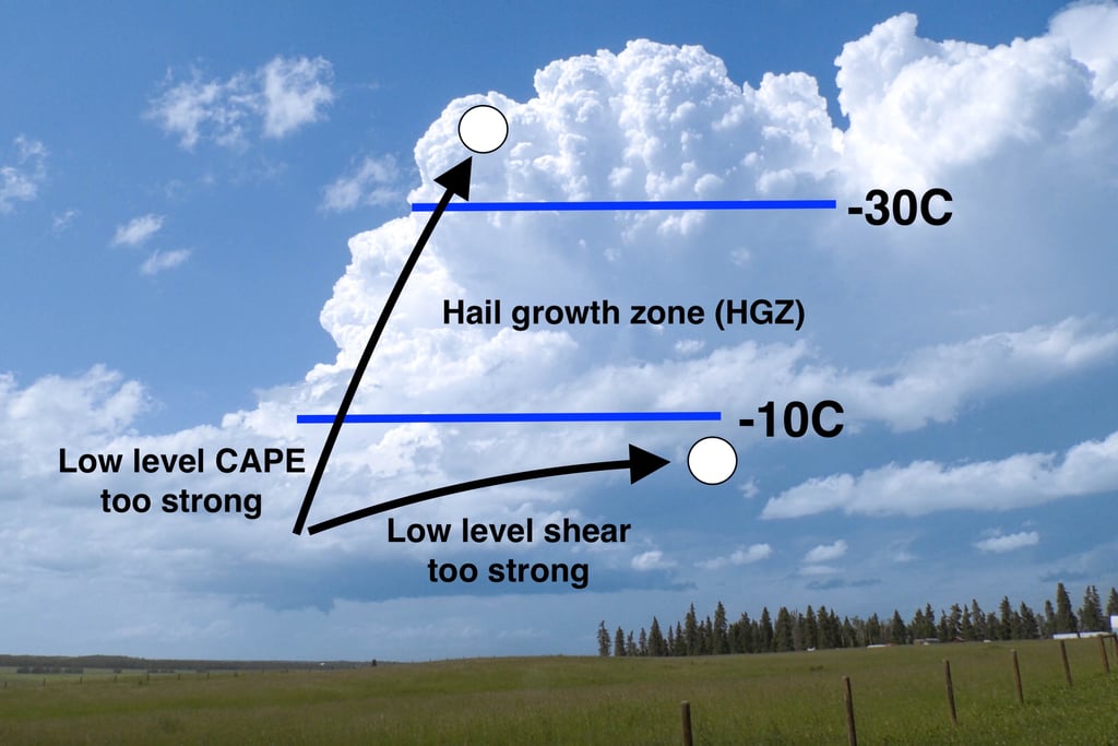

Figure 11: Sub-optimal trajectories for hail growth, imparted by strong low-level buoyancy and shear. Figures 11 and 12 adapted from conceptual diagrams by Cameron Nixon.


Figure 12: Optimal trajectory for the growth of large hail.
As a result, the hodograph shapes associated with significant tornado environments tend to look different from those linked to prolific hail producers. Tornado-favourable environments often feature very strong low-level wind shear, with much of the total shear concentrated in the lower atmosphere. On a hodograph, this commonly appears as pronounced low-level looping, producing a curved or “sickle" shape. Additional curvature or backing above the inflow layer, combined with sufficient overall length, indicates strong deep-layer shear capable of supporting supercell thunderstorms that may produce tornadoes.
In contrast, environments that favour large hail typically show relatively weak wind shear in the lowest kilometre of the atmosphere, with stronger shear developing higher up. This produces a longer, straighter hodograph shape. While hodographs alone cannot predict hail size, this general pattern provides forecasters with a useful rule of thumb to quickly assess the primary hazard type at first glance.
Part four: The meteorology of Calgary's top 7 destructive hailstorms
Data sources
For each of the seven cases, a 500mb analysis and surface analysis (with auto-analyzed fronts) are used to assess the synoptic background environment of the immediate, pre-storm environment. Additionally, a reanalysis sounding and hodograph are presented, given the absence of proximity soundings and the distance from Alberta's only balloon launch site, west of Edmonton. Each case contains a discussion section.
For the 7 September 1991 case, the upper air map was retrieved from the Plymouth State Weather Center. The reanalysis sounding and hodograph was based on ERA5 data and was retrieved from rawinsonde.com.
For all cases, surface observations were retrieved from NOAA's WPC. For all cases after 1991, 500mb analyses are retrieved from the SPC's mesoanalysis archive, due to its higher spatial and temporal resolution, despite Calgary being near the edge of the map domain. Additional 500mb analyses are linked, showing the broader upper air picture based on the 12Z observations of the storm day. Reanalysis soundings for all cases after 1991 are from SounderPy: 12 July 2010 uses RUC data, while the remaining five use RAP.
Reanalysis soundings may have known biases:
ERA5 soundings struggle near major terrain barriers, and with westward extent across North America. They may underestimate CAPE, low level moisture, and low level shear - but do better with mid-level temperature and winds.
RUC soundings may have a near-surface cool and dry bias, and also tend to underestimate CAPE
RAP soundings may have a near-surface warm and dry bias
All reanalysis soundings were selected based on proximity to the storm and the nearest, uncontaminated surface observations prior to the storm. RUC and RAP reanalysis soundings were modified to include the most recent surface observations, which were retrieved from ECCC's climate archive. ECCC's archived radar was also consulted for all cases after 1991.
In the discussion section of each case, the evolution of surface and upper air features may be referenced but not shown. These can be found by clicking the links above, and explored as desired. Only single upper air and surface snapshots of the pre-storm environment are shown as figures.
7 September 1991
Time: Between 6-8PM MDT
Insured damage (2023 dollars): $650 million
Maximum hail size: Tennis ball
Radar: Not available.
YYC Observations: Link

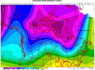
Figure 13: 500mb height analysis at 6PM MDT, 7 September 1991. Credit: Plymouth State Weather Center.
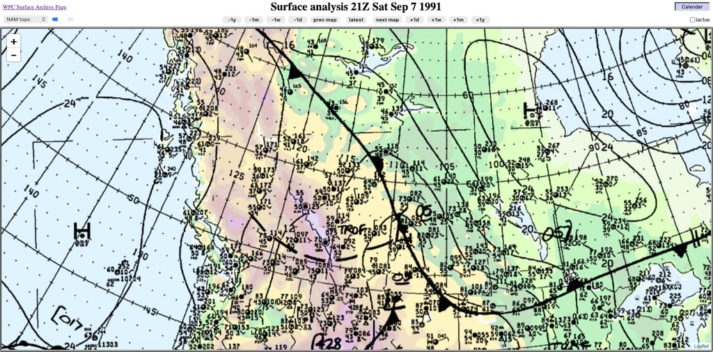
Figure 14: Surface analysis at 6PM MDT, 7 September 1991. Credit: NOAA.
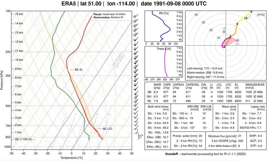
Figure 15: ERA5 reanalysis sounding and hodograph for 6PM MDT, 7 September 1991 in Calgary. Credit: rawinsonde.com
Discussion
(Storm timing and location for this late-season event were estimated based on surface observations and newspaper clippings from the Calgary Herald. No archived radar is available).
Aloft, a significant upper trough is present over British Columbia, with strong, mid-level southwesterly flow over Alberta (Figure 13). The approaching upper trough would serve to cause mid-level cooling and ascent while increasing vertical shear, increasing the favourability of severe thunderstorms in accordance with Smith and Yau's conceptual model.
Surface fields evolve consistent with the approaching upper trough and strengthening cross-barrier flow, with surface lee trough development about 18 hours prior to the event - and lee cyclogenesis over southern Alberta shortly after. As the low slowly moves east into Saskatchewan, northerly winds flow southward behind it to meet southwesterly winds in southern Alberta along a QS front (Figure 14). In Calgary, skies are mainly cloudy, with surface winds gradually veering to northeasterly throughout the day.
The ERA5 reanalysis sounding reveals modest CAPE values of under 1000J/kg, with some convective inhibition (Figure 15). The relatively light northeasterly surface winds beneath strengthening southwest flow aloft create a long, straight hodograph. The somewhat moderate storm-relative inflow and strong 0-6km shear might serve to create a broader updraft. Without the availability of radar, it is unknown whether any storm mergers occurred.
The presence of overcast skies may have served to weaken the mountain-plain circulation, if present at all. The environment seems to support the possibility of the storm being at least somewhat elevated. The lack of a higher-resolution 500mb analysis precludes our knowledge of any embedded vorticity maxima that may have supported the storm. Surface pressures continued to slightly fall until the storm hit.
12 July 2010
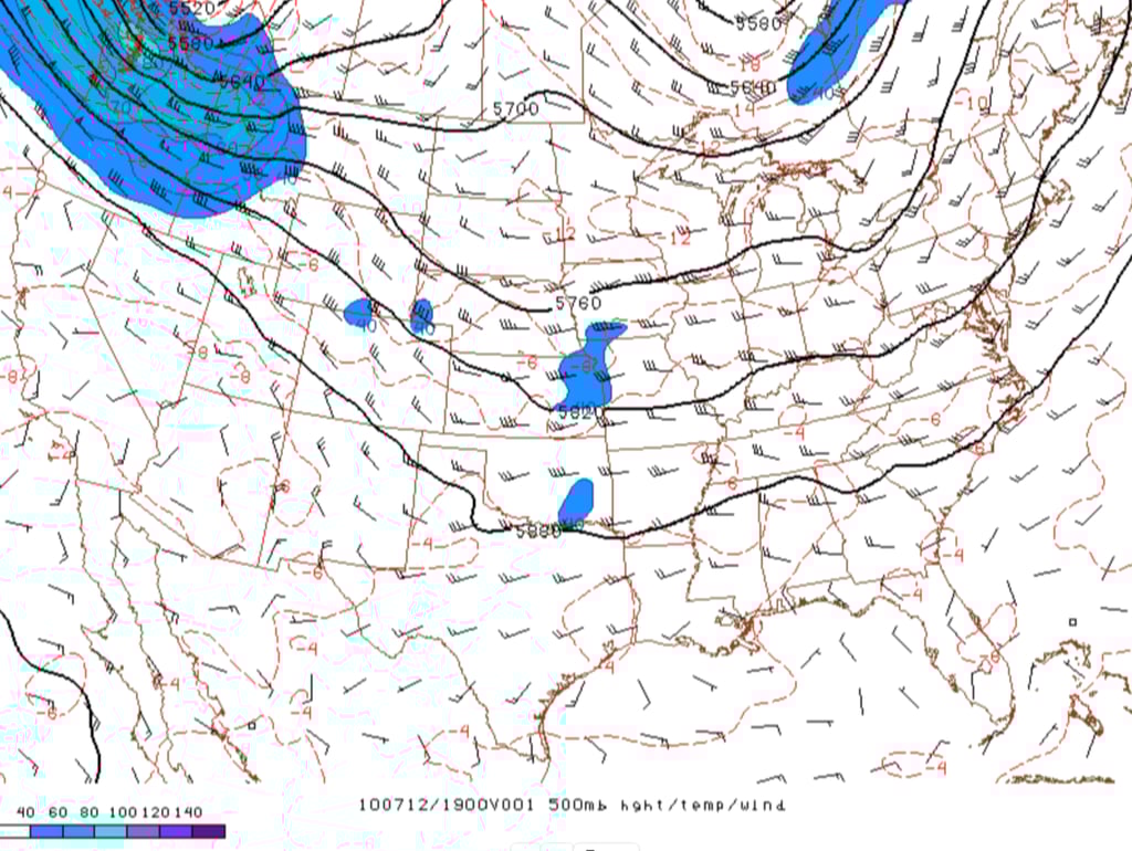

Figure 16: RUC 500mb height and wind analysis at 1PM MDT, 12 July 2010. Credit: NOAA/SPC.
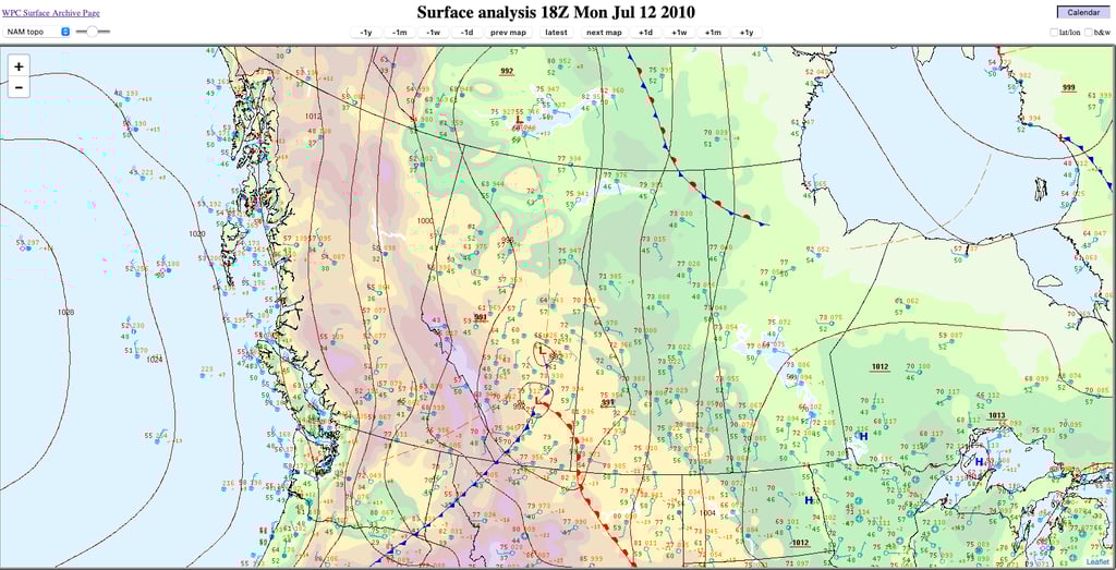
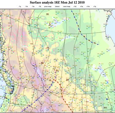
Figure 17: Surface analysis at 12PM MDT, 12 July 2010. Credit: NOAA.


Figure 18: RUC reanalysis sounding at 1PM MDT, 12 July 2010 in Calgary. Credit: rawinsonde.com
Discussion
An upper low is moving southeastward over central and northern British Columbia, with a strong mid-level jet stream rounding its base into Washington (Figure 16). A moderate, diffluent southwesterly flow aloft is present over Alberta, which is also beneath the left exit region of the upper jet (not shown).
In response to strengthening cross-barrier flow, lee troughing began over Alberta late the previous evening - with lee cyclogenesis occurring north of Brooks by midday (Figure 17). In a similar evolution to the previous case (though more recent), this brought moderate northerly winds into the Calgary region to the west of the developing low by late morning, which veered to north-northeasterly until storm time. Skies were again mainly cloudy, although likely not with optically-thick low level clouds, given the surface temperature attained.
The RUC reanalysis sounding reveals weak to moderate CAPE, with steep lapse rates above a layer of appreciable CIN (Figure 18). Over the lowest 8km, the hodograph is relatively long and straight, with backing in the low levels consistent with a cold advection regime to the west of the low. Again, the overall environment suggests the potential of storms that could be at least somewhat elevated.
Archived radar (base reflectivity) reveals that the parent storm was initially quite small, and appeared multicellular as it moved through the city of Calgary. The coarseness of the radar imagery and lack of velocity data precludes confirmation of updraft rotation, but the hodograph suggests low level shear was generally unfavourable.
12 August 2012

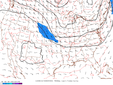
Figure 19: RAP 500mb height and wind analysis at 9PM MDT, 12 August 2012. Credit: NOAA/SPC.
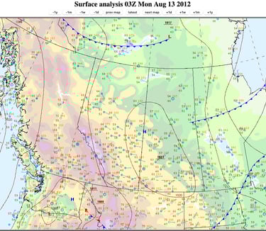
Figure 20: Surface analysis at 9PM MDT, 12 August 2012. Credit: NOAA.

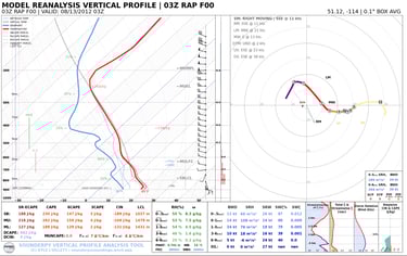
Figure 21: RAP reanalysis sounding and hodograph at 9PM, 12 August 2012 in Calgary. Credit: rawinsonde.com
Discussion
A broad, moderate west-northwesterly flow aloft is present over Alberta (Figure 19), with weak ridging between two upper troughs.
At the surface, a ridge of high pressure is in place across eastern Alberta (Figure 20), behind a large-scale cold front associated with an earlier low that tracked from the Northwest Territories into Hudson Bay. As the surface ridge moves slowly east, a relatively moist southeasterly upslope flow develops along the Alberta foothills.
The RAP reanalysis sounding reveals notably weak CAPE, substantial convective inhibition, and a lofty LFC (Figure 21). Given the late time of day, much of the CIN is likely the result of the developing nocturnal inversion. The hodograph reveals appreciable low level shear, but the presence of excess CIN likely results an elevated effective inflow base. Above this, the hodograph is relatively long and straight.
Radar indicates that an initial storm developed along the central foothills west-southwest of Rocky Mountain House in the mid-afternoon. This storm tracks southeastward down the foothills, supported by an embedded upper disturbance and feeding off continued convergence, allowing it to persist for many hours.
Mid-evening, a new storm develops to its immediate southwest. The two storms eventually merge just north of Cochrane by 9PM MDT, creating a larger and more intense supercell just prior to its arrival in north Calgary.
7 August 2014
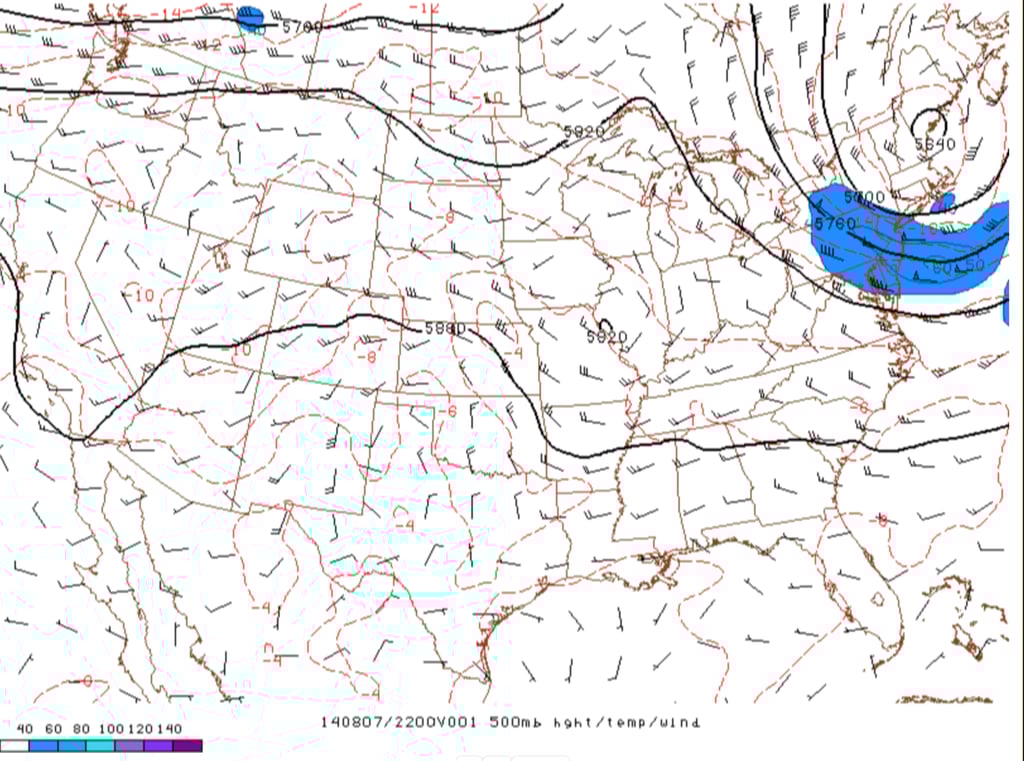
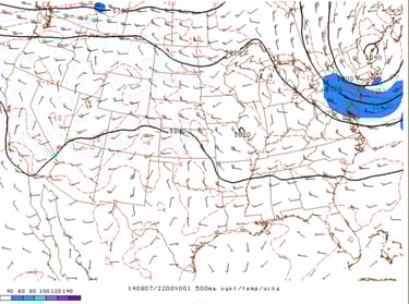
Figure 22: RAP 500mb height and wind analysis at 4PM MDT, 7 August 2014. Credit: NOAA/SPC.
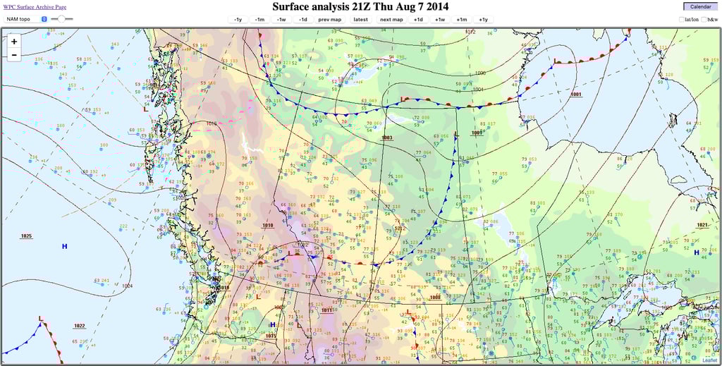
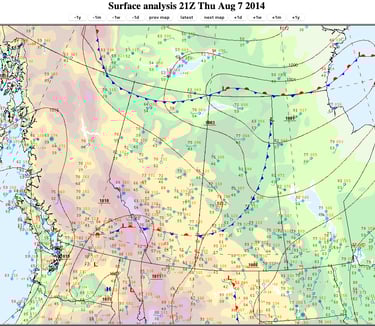
Figure 23: Surface analysis at 3PM MDT, 7 August 2014. Credit: NOAA.

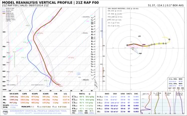
Figure 24: RAP reanalysis sounding and hodograph at 3PM MDT, 7 August 2014 at Nier AGDM, just northwest of Airdrie. Credit: rawinsonde.com
Discussion
Aloft, a broad, moderate west-southwesterly flow is in place over Alberta (Figure 22), with a shortwave trough well off the British Columbia coast, and another shortwave over far northern Alberta.
At the surface, a broad area of low pressure is present over far northern Saskatchewan and Manitoba, with a weak cold front trailing southwestward across the Prairies that stalls in the Calgary area (Figure 23). North of the front, light northerly winds have shifted to easterly and strengthened somewhat by mid-afternoon - perhaps in part due to the mountain-plain circulation.
The RAP reanalysis sounding reveals moderate CAPE values in a more classic-looking profile associated with severe weather outbreaks in Alberta (Figure 24). While winds veer with height, a weakness in low level winds above the surface creates a long, straight hodograph with almost no shear in the 0-1km layer.
Radar indicates that the storm initiated west of Cochrane, and soon split into right and left-moving supercells - which is the expected storm evolution given the environment. The right split moved slowly eastward toward Airdrie, before producing the damaging hail in the city. The relatively weak storm-relative inflow and lack of subsequent mergers resulted in a relatively smaller storm, but the slow storm motion ensured damage was nonetheless maximized.
Airdrie would go on to be hit by two more storms later in the day, amid an outbreak of prolific hail-producing supercells across south-central Alberta.
13 June 2020
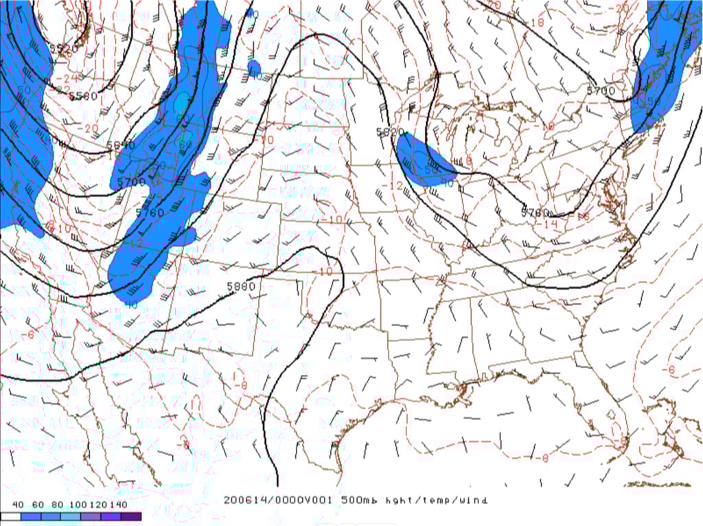
Figure 25: RAP 500mb height and wind analysis at 6PM MDT, 13 June 2020. Credit: NOAA/SPC.
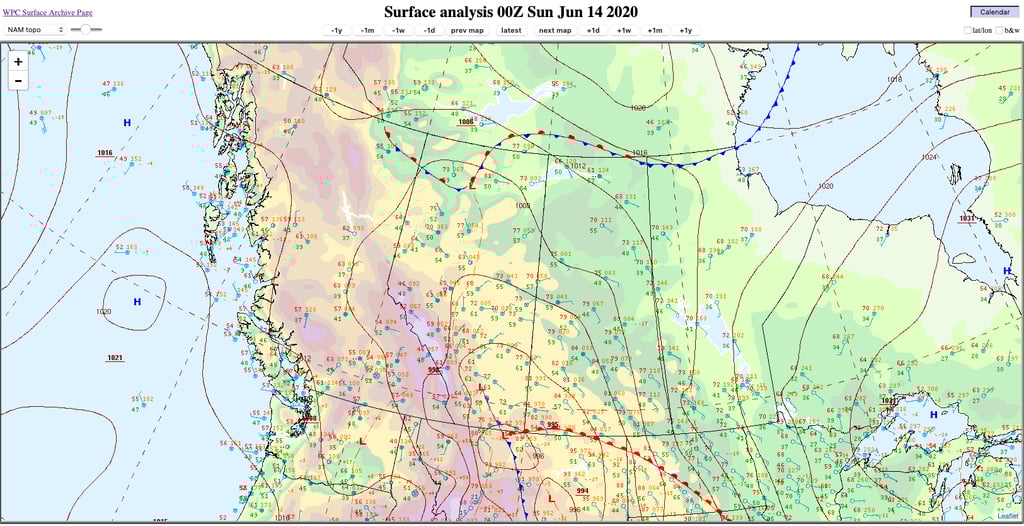
Figure 26: Surface analysis at 6PM 13 June 2020. Credit: NOAA.

Figure 27: RAP reanalysis sounding and hodograph at 6PM ,13 June 2020 in Calgary. Credit: rawinsonde.com
Discussion
An upper low sits just off Vancouver Island, with an energetic, negatively-tilted shortwave trough rotating through the western United States (Figure 25). This drives a moderate to strong mid-level jet from the US Desert Southwest into Alberta, with several embedded vorticity maxima.
At the surface, cyclogenesis occurs in northern Montana by late afternoon 13 June. An inverted trough extends well into Alberta, driving a moist, northeasterly flow into the Calgary area (Figure 26).
The RAP reanalysis sounding shows moderate CAPE, while the hodograph is quite straight through 6km in nearly unidirectional southerly flow aloft (Figure 27). Once again, 0-1km shear is almost negligible, increasing rapidly above. Similar to the 7 August 2014 case, there is appreciable low level CAPE that could support strong, low level vertical accelerations. However, this is tempered somewhat by the weak shear in the 0-1km layer.
Radar imagery shows an interesting evolution, as a line of showers and thunderstorms associated with an embedded impulse moves north toward the Calgary area. Near the leading edge of the precipitation, a line of thunderstorms erupts over south Calgary around 630PM MDT, at the same time that a northwestward-moving pair of (presumably) low-topped thunderstorms approach the area from the east.
The initial storms continue to intensify over central Calgary at the same time that a cell from the east merges into them. The storm displays the most intense echoes following the merger, becoming quite large while also slowing down as it tracks across far northeast Calgary. Given the relatively weak storm-relative inflow in the environment, it seems much of the this mass was derived from the merger. The storm appeared quite messy on radar, but appeared to display some transient supercell characteristics.
2 July 2021
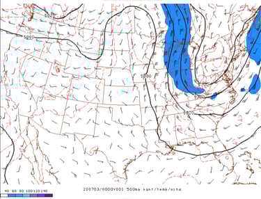
Figure 28:
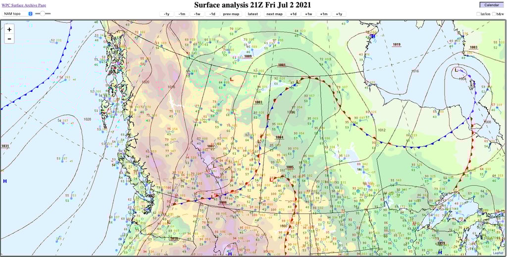
Figure 29:
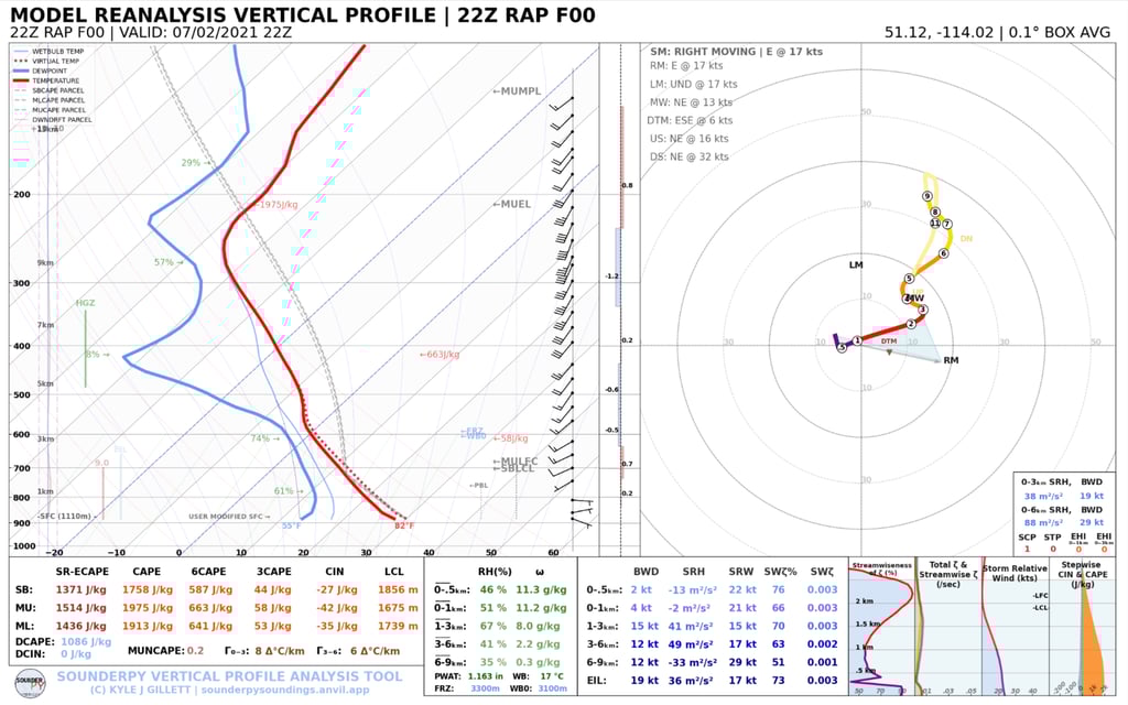
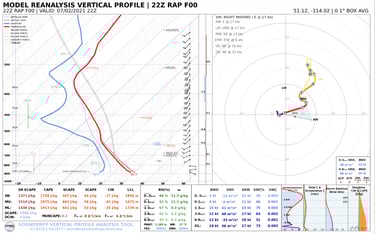
Figure 30:
Discussion
Aloft, the upper ridge associated with the infamous 2021 Heat Dome moves east into the eastern Prairies as it continues to break down, bringing modest southwesterly flow aloft into Alberta (Figure 28). An upper disturbance is moving through far northeastern Alberta, with another one approaching southern Alberta from the west.
At the surface, an elongated area of low pressure extends through northeastern Alberta and northwestern Saskatchewan, with a QS front extending southwestward into southern Alberta (Figure 29). North of the frontal zone, northerly winds begin veering more upslope over time. Post-frontal winds are relatively moist and still quite warm as the hot air mass lingers over the region following the past few days of record heat.
The RAP reanalysis sounding reveals moderate CAPE with high LCLs (Figure 30). 0-1km shear is very weak, with a relatively straight hodograph to 7km. Vertical shear is weaker overall, owing to the lack of baroclinity in the expansive warm air mass across much of the continent, resulting in more of a multicell storm environment.
Strong, mid-level forcing associated with the approaching disturbance supports a slow-moving area of showers and thunderstorms, with several rounds of thunderstorms through Calgary between 430-7PM MDT. The only damaging hailstorm that occurs in south Calgary of these seven cases moves through far southern areas of the city between 6-630PM MDT.
Radar indicates that several cell mergers occurred prior to the event, creating a larger multicell cluster as it entered south Calgary. The relatively dry boundary layer likely aided in the development of a bow echo, causing strong wind gusts that compounded the hail damage.
5 August 2024
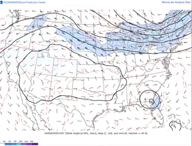
Figure 31:
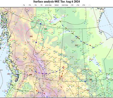
Figure 32:
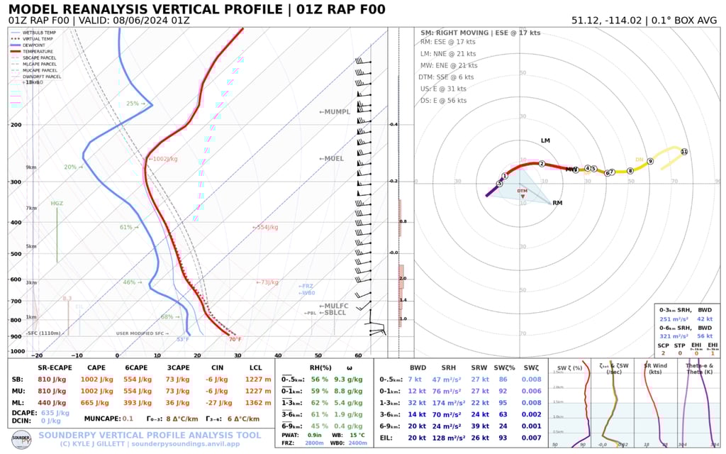

Figure 33:
Discussion
Aloft, an upper trough extends from northwestern Alberta into the Pacific west of Oregon. Moderate west-southwesterly winds flow through a broad upper ridge extending from the western Prairies into the southwestern United States. A notable, ridge-riding disturbance approaches southern Alberta by early evening.
At the surface, a lee trough develops across Alberta late the previous evening, with weak cyclogenesis occurring near Brooks overnight. During the day, the low moves east into west-central Saskatchewan, with light northeasterly winds blowing toward the foothills to its west. Northeasterly winds strengthen in response to the approaching upper disturbance, with a new low forming in southeastern Alberta by late evening.
The RAP reanalysis sounding shows weak to moderate CAPE, and a long, straight hodograph. There is at least some low level curvature in the hodograph (especially after being manually modified to reflect surface observations), but low level CAPE is modest.
Radar indicates that two significant storms tracked through areas near and south of Calgary during the evening, ahead of the upper disturbance. According to reports, both storms produced large hail. The northern storm (that impacted Calgary) was a large storm that displayed supercell characteristics, with a progressive RFD that bowed out and forced new cells along its outflow. The storm's large size was likely aided by moderately strong storm-relative inflow and strong deep layer shear, producing copious amounts of wind-driven hail.
Part five: Putting the pieces together
Damaging hailstorms in the Calgary area have been shown to occur in a number of different meteorological environments. Calgary's 7 costliest hailstorms to date have occurred:
During the months of June, July, August, and September
At any time between 130PM and 11PM MDT, with 4/7 cases between 6-9PM MDT
With relatively slow storm motions of between 26-42km/h, maximizing hail accumulation and damage
Disproportionately in northern areas of the Calgary region (6/7 cases)
Mostly in a west-to-east or northwest-to-southeast track (6/7 cases)
In both locally wet and dry years, regardless of the presence of local drought
Despite the differences in meteorological environments and the small sample size of cases, a number of important similarities also appear to arise. These may help in creating a conceptual model for the occurrence of destructive hailstorms in the Calgary region, and include:
At least weak to moderate CAPE, with many environments having notably low CAPE values below 1000J/kg
A long, straight hodograph shape, usually with strong (>40 knot) 0-6km shear
Weak or negligible shear in the 0-1km AGL layer, with shear rapidly increasing above
An upstream, mid-level vorticity maximum that supports storm development and maintenance
Additionally, since broad updrafts are thought to be more favourable for the efficient growth of large hail, at least moderate (>20 knot) storm-relative inflow should be present, and/or the occurrence of cell mergers, to create larger storms. The low level thermodynamic environment may favour either surface-based or elevated storms, but strong vertical accelerations above the ground caused by strong low level CAPE and/or low level shear may be unfavourable for optimal hail growth. If one is stronger, its effects may be somewhat offset by the other being weaker. The relative novelty of these past two theories warrants further investigation in future cases.
Parent storms may be supercells, but sometimes occur with little or no updraft rotation, revealing that multicell storms may still be capable of producing large, damaging hail. Moreover, the presence of strong, convective wind gusts can make hail more damaging by increasing both its angle of attack (enabling it to hit the sides of objects, in addition to the tops) and its impact force.
The above environments can come about in a variety of ways, but a common way that has emerged from these cases involves a post-frontal environment, with light to moderate low level winds nearly opposite in direction to stronger jet stream winds above. This can occur either immediately following the passage of a cold front, or some time after a weaker synoptic cold front has passed through the region, creating a light, northeasterly (upslope) surface flow. When flowing beneath a strong jet stream aloft, this profile frequently creates a long, straight hodograph with weak low level shear.
Given the relatively weak CAPE characteristic of such a post-frontal environment, these setups may be easier to overlook. However, it has been seen that damaging hail events can occur with weak (<1000J/kg) CAPE. Significant cloud cover is also often present in such environments, which may reveal a reduced overall importance of the mountain-plain circulation that is a key part of the Smith and Yau conceptual model of severe thunderstorm outbreaks in Alberta.
Conclusion
Awareness of meteorological environments favourable for the development of thunderstorms capable of producing large, damaging hail is critical for forecasters. Identifying these patterns helps inform messaging that allows the public to make preparations ahead of time. While a variety of atmospheric setups can produce these conditions in the Calgary area, several key features appear repeatedly in past cases.
At the same time, these events must also be considered in a broader societal context, as their impacts have become increasingly costly. The growing trend of catastrophic hailstorms in Calgary is placing significant strain on the insurance industry, prompting wider discussion about how to build community resilience as insurance premiums continue to rise. According to the Insurance Bureau of Canada, recommended measures include:
Stronger building codes, with broader use of impact-resistant building materials
Government financial support for retrofits
Enhanced risk mapping of hail-prone areas
Improved early warning systems
Continued improvements in forecasting, combined with the implementation of these mitigation measures, can help Calgarians better prepare for severe hail events while reducing the damage associated with what remains an inevitable hazard in southern Alberta.