Why Have Canada's Wildfire Seasons Suddenly Gotten Worse?
Kyle Brittain
10/12/2025
Canada’s wildfire seasons are getting worse.
Of the past five wildfire seasons, four have seen well-above average area burned across the country. There have been several wildland urban interface disasters. Wildfire smoke has plagued millions across the continent with poor air quality for days on end.
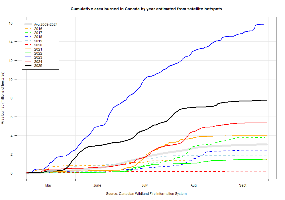
Four of the past five wildfire seasons have seen well above the 2003-2024 average of area burned in Canada, including 2021, 2023, 2024, and 2025. Credit: Natural Resources Canada.
So, what is driving the recent change?
In this blog post, I will attempt to make the case that rapidly changing ocean temperature patterns across the North Pacific – influenced in large part by human activities – are playing a key role in increasing fire weather conditions in much of Canada.
Natural climate variability influences area burned in Canada
Climate change occurs over long periods of time. Recent trends are typically assessed by comparing the 30-year averages of certain variables in the atmosphere and oceans. Within those longer timeframes exist periods of shorter-term but significant variability. For instance, some years may be much warmer in certain areas of Canada than others. Such effects are often tied to oscillating patterns of sea surface temperatures in different areas of the world, which can influence the weather thousands of kilometres away.
The El Niño-Southern Oscillation (ENSO), occurring in the tropical Pacific, is the most important climate driver influencing year-to-year variability in Earth’s climate system. Outside the tropics, the Pacific Decadal Oscillation (PDO) plays a significant role in climate variability across the North Pacific – and will be very important in our current discussion. The PDO occurs on longer time scales, and has a warm (positive) phase, along with a cool (negative) phase.
Warm PDO phases are “El Niño-like”, and have warmer than average sea surface temperatures along the west coast of North America – with cooler than average sea surface temperatures across the western and central North Pacific. Cool PDO phases are “La Niña-like”, and present with just the opposite pattern of sea surface temperature anomalies.
Both patterns can influence the atmosphere in ways that make fire weather more or less common across Canada in a given season.
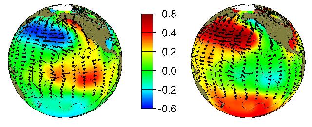
Typical sea surface temperature (SST) anomaly patterns with the PDO. Credit: NOAA.
Research has shown that in the past, warm PDO (+PDO) conditions generally led to greater area burned east of the Rockies in Canada. Conversely, cool PDO (-PDO) conditions generally led to less area burned east of the Rockies – with more area burned west of the Rockies in British Columbia.
Where we are at now
We're presently in a cool PDO regime, with the PDO index becoming increasingly negative since about 2020. In July 2025, it hit an all-time record low of -4.12 – likely driven largely by the extreme warmth in the western Pacific near Japan and eastward along the Kuroshio Extension. Except for the strong El Niño in the winter of 2023/24 (out of phase with the strongly negative background PDO), ENSO has frequently been in cool neutral or La Niña territory.
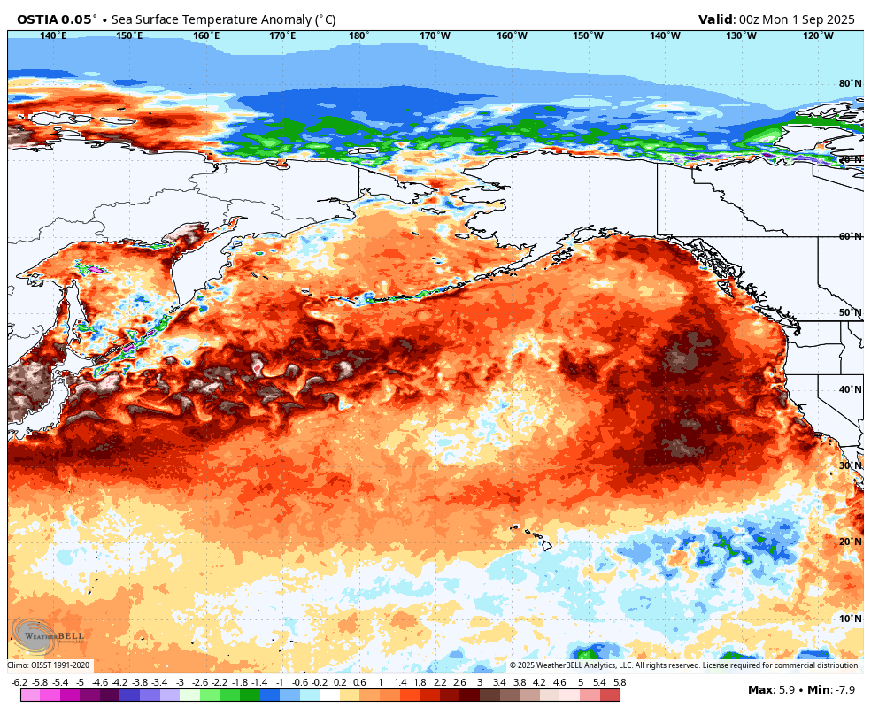
Sea surface temperature anomaly across the North Pacific as of the end of summer 2025, based on OSTIA 5km SST. Credit: Weatherbell.
In this current climate regime, widespread drought and national area burned have increased since 2021.
Unlike the typical -PDO sea surface temperature anomaly pattern, much of the eastern North Pacific has also frequently been warmer than normal during the summertime – resulting in basin-wide warmth. In addition to the western Pacific, there have been several marine heat waves, or “blobs” of anomalously warm water that have formed in the eastern North Pacific – near the west coast of North America.
Finally, despite typical patterns of area burned during -PDO regimes, there has been significant area burned on both sides of the Rockies in recent years. This has especially been the case in the western half of the country.
Broadly speaking, sea surface temperature anomaly patterns across the North Pacific have been quite consistent since 2021. These have also had a fairly consistent influence on patterns of winds and pressure in the atmosphere above, which have been influencing the weather downstream in North America.
Let’s look at the average position of some of these key features in the oceans and atmosphere during the summers of 2021-2025, using ERA5 reanalysis data.
How the oceans are influencing the atmosphere
During boreal summer (June, July, and August) in recent years, the warmest sea surface temperature anomalies have been focused in the western and central Pacific. This has largely been driven by the Kuroshio Current (a climatologically warm, western boundary current east of Japan), which has been much warmer and farther north than normal. This is pumping warmth eastward across the ocean along the North Pacific Current.
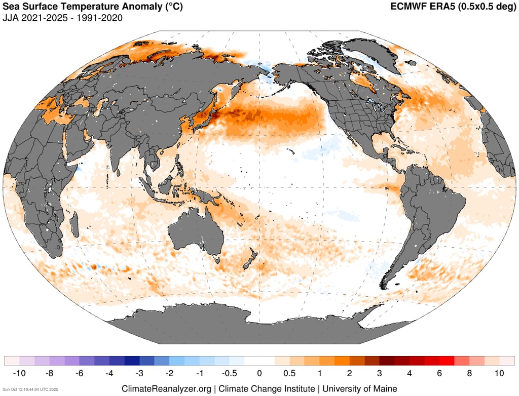
Global sea surface temperature anomaly during the months of June, July, and August (JJA) from 2021-2025. Credit: Climate Reanalyzer.
This sea surface temperature pattern has influenced the summertime jet stream, initiating a wave train that frequently sets up across the North Pacific and North America.
The result is mean, positive geopotential height anomalies ("ridging") at 500mb in areas east of Japan, over western Canada, and just east of Newfoundland. Mean troughing centres exist in higher latitudes near Beringia and over the Davis Strait.
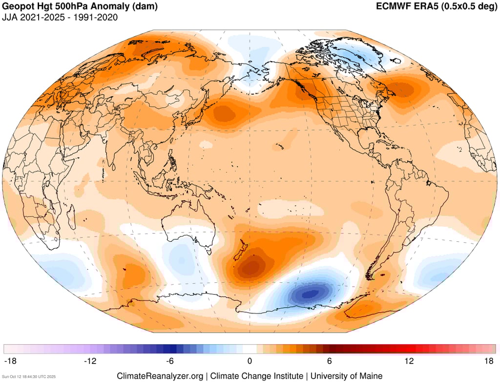
JJA Global 500mb geopotential height anomaly, from 2021-2025. Credit: Climate Reanalyzer.
The pattern of 500mb wind speed anomalies reveals a summertime jet stream that is further north than normal.
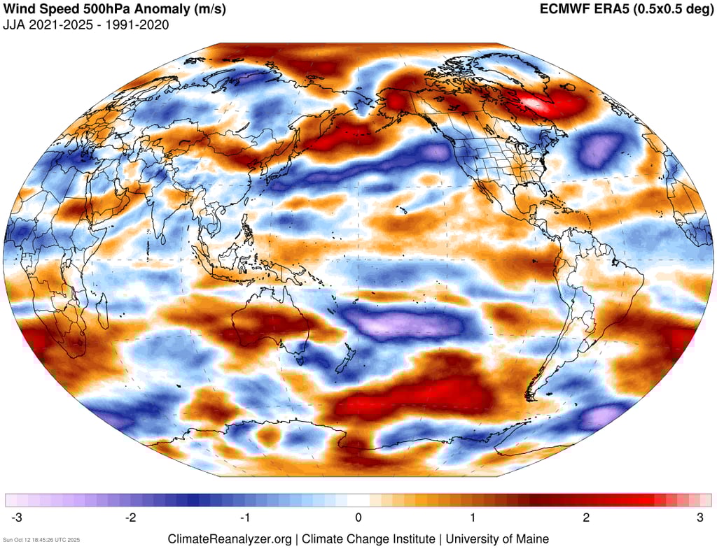

JJA Global 500mb wind speed anomaly, from 2021-2025. Credit: Climate Reanalyzer.
This pattern of upper height and wind anomalies has important implications for prevailing weather conditions during the summer across North America.
Perhaps the most critical atmospheric feature in influencing the severity of fire seasons in Canada has been the strong, mean upper ridging over the western half of the country. This causes large-scale sinking air, and an abundance of hot and dry weather – while also blocking the flow of Pacific moisture from the west. This sets the stage for drought development over much of Canada. And drought tends to beget more drought in continental climates.
ERA5 reanalysis of temperature reveals that summers since 2021 have been much warmer than normal across western and northern areas of North America.
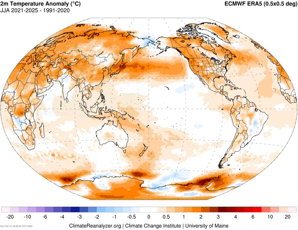
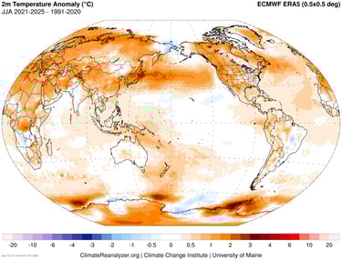
JJA Global surface temperature anomaly, 2021-2025. Credit: Climate Reanalyzer.
Skies have also been clearer than normal during the summer across much of Canada, with less precipitation than normal in central and western areas of the country.
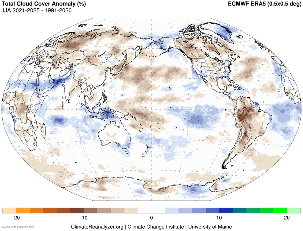

JJA Global total cloud cover anomaly, 2021-2025.
The mean upper ridging and poleward-shifted storm track has resulted in clearer skies and lighter winds across much of the North Pacific, as well as east of Atlantic Canada. This results in a higher frequency of marine heat waves in these regions. This is reflected in the above graphic of sea surface temperature anomaly, with the North Pacific warm pool extending toward the west coast of North America in the summer.
Extreme fire weather has become more common in the West
Rapid wildfire growth is favoured when fuels are dry and the weather is hot, dry, and windy. Wildfire seasons in regions with large area burned tend to have excess fire weather.
Area burned can be a tricky metric to gauge the overall severity of a wildfire season, though. Fire managers in some areas may utilize modified suppression approaches that result in large area burned. Some years may see fewer human-caused fires that reduce area burned, despite otherwise great potential for massive spread. And of course, a year with less area burned overall may still be remembered for a single, disastrous urban interface event.
Still, large area burned won’t occur without ample fire weather conditions. Therefore, it can be helpful to look at other metrics, such as anomalies in the Fire Weather Index (FWI) to get a sense of overall fire weather trends across North America.
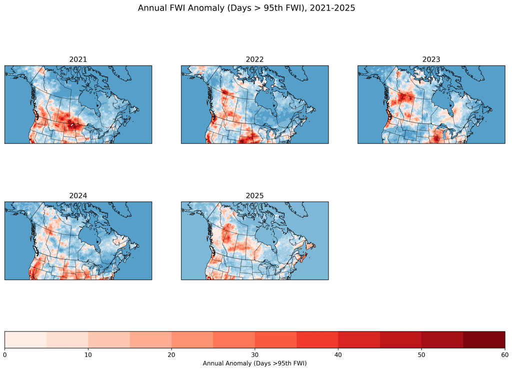
The current climate regime has resulted in excess extreme fire weather days across much of western Canada in recent years. This has been especially true in the region of northeastern British Columbia, northwestern Alberta, and southern Northwest Territories – a significant percentage of which has burned in recent, multi-year fires. Lesser but still significant anomalies across other parts of western North America, including from southern British Columbia down the west coast of the United States.
It comes as no surprise, then, that national area burned has greatly increased since 2021.
Reductions in air pollution are warming the ocean
In recent years, the North Pacific has been rapidly warming. In fact, as of the end of summer 2025, it was the warmest ever recorded.
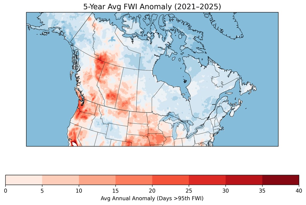
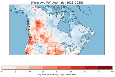
Maps of annual FWI anomaly across Canada, from 2021-2025. Reds are areas where extreme fire weather days were above normal for the season.
5-year average FWI anomaly in Canada from 2021-2025. (Special thanks to Piyush Jain for providing me with the latest FWI anomaly data to complete these maps in Python).

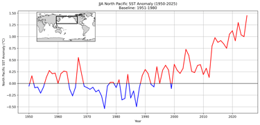
JJA North Pacific sea surface temperature anomaly from 1950-2025, based on the 1951-1980 baseline, using the NOAA ERSSTv5 dataset.
A major driver in recent North Pacific warming has been the sudden reduction of sulphate aerosol pollution.
When fossil fuels are burned, they give off greenhouse gases (like CO2) that have a warming effect on the atmosphere – along with gases (like SO2) that are the precursor of aerosol pollution (like sulphate aerosols), which have a cooling effect. The latter “hides” some of the warming from greenhouse gases through the aerosol masking effect. Aerosols have a cooling effect by increasing the scattering of sunlight and increasing the albedo (brightness) of clouds, so that less of the sun’s energy is absorbed at the surface.
However, the microscopic airborne particles that comprise aerosol pollution are one of the leading causes of premature death in the world. Scrubbing them from fossil fuel emissions is therefore desirable. But it comes at the expense of potentially rapid warming, due to its unmasking of the warming effect of greenhouse gases. Because aerosols have a much shorter residence time in the atmosphere than greenhouse gases, their sudden removal can result in rapid, observable changes. There are few better examples of the direct impact of human actions on Earth’s climate system.
In recent years, emissions of sulphur dioxide have been drastically cut. Two notable examples include the recent cleanup of East Asian air pollution, and the 2020 IMO regulatory cap on sulphur in shipping fuels.
One of the effects that has been observed since IMO2020 is a significant reduction in ship track clouds. Sulphate aerosols act as cloud condensation nuclei, on which water vapour can condense into cloud droplets. When removed from the atmosphere, fewer clouds form. This results in more absorption of the sun’s energy in the oceans, and more warming, with the effect being maximized near the world’s busiest shipping lanes. Elsewhere, clouds that do form (like marine stratocumulus) are dimmer, and reflect less light. While the overall effect may be relatively small in the global system, it’s playing a role in the warming of the oceans.

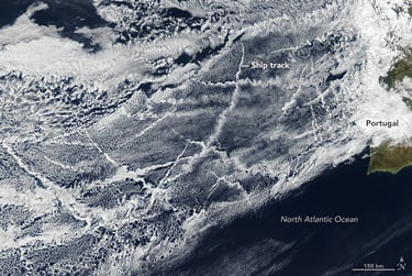
Ship track clouds as seen in the eastern North Atlantic on January 16, 2018. Credit: NASA.
Perhaps a more significant example of SO2 reductions has come from China – and more broadly, East Asia in recent years. Between 2013-2019, China’s clean air action plan resulted in massive reductions of sulphur dioxide, bringing about significant declines of aerosol pollution over East Asia and downwind areas of the Pacific. This can regionally reduce albedo, resulting in warmer sea surface temperatures across much of the North Pacific. In fact, research has shown that reductions in East Asian air pollution can even increase the frequency of marine heat waves as far away as near the North American coast.
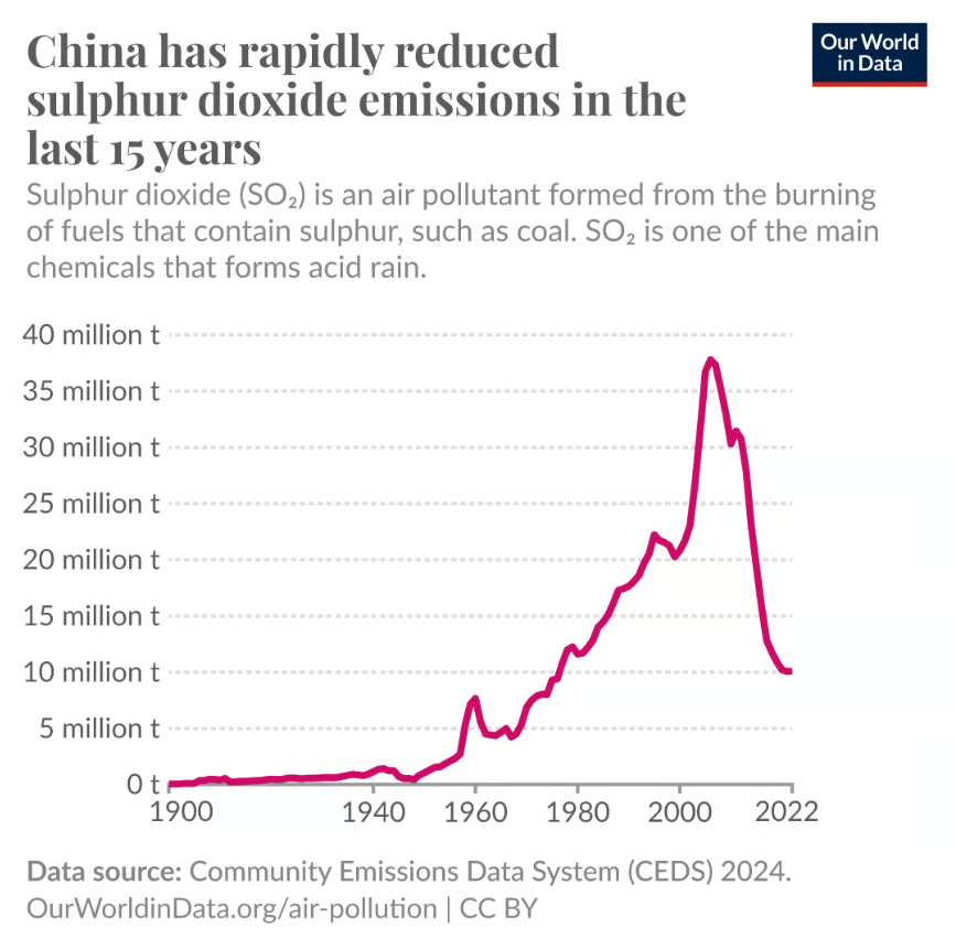
Emissions of sulphur dioxide (SO2) in China, from 1900-2022. Credit: Our World in Data.
That better air quality may come at the expense of rapid global warming is a concerning dilemma. Indeed, it has motivated efforts to research certain geoengineering schemes that could reintroduce the aerosol masking effect, such as stratospheric aerosol injection, or marine cloud brightening. However, these have not yet been implemented on the large scale due to the concern of negative, unintended consequences on the global climate system.
Pacific Ocean warming appears to be influencing Canadian wildfire seasons
It is interesting to note how different the current, cold PDO regime looks compared with others in the recent past. This includes 1998-2002 and 2007-2013, when temperatures in the eastern North Pacific and over adjacent areas of western North America tended to be cooler than normal during the summer. It is clear that in recent years, something has changed – and that this change likely can’t be accounted for by natural climate variability alone.
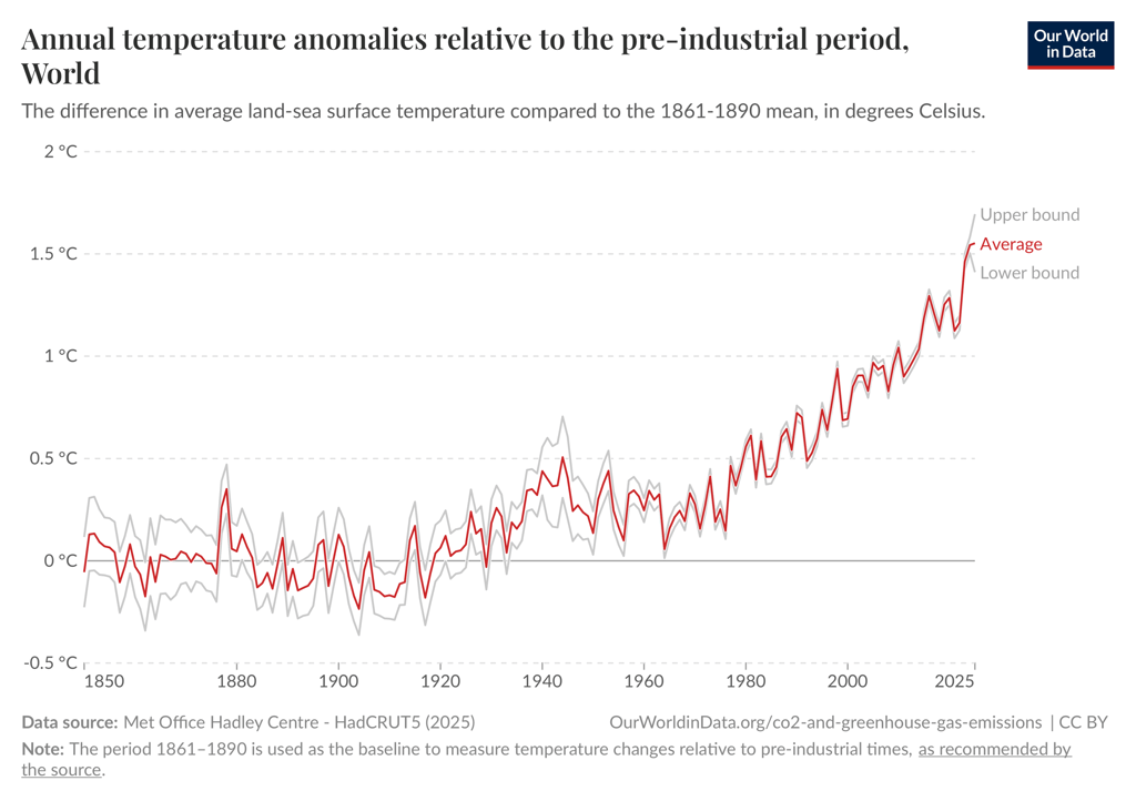
Global average surface temperature anomaly from 1850 to present. Credit: Our World in Data.
If we step back to look at the big picture for a moment, global average surface temperature has really begun to increase since the late 1970s or early 1980s – around the time that SO2 emissions (and sulphate aerosol pollution) had peaked and began to decline. These reductions occurred in Europe and the Americas first, with later declines truly beginning in Asia since about 2013.

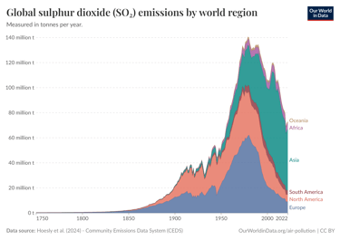
Global sulphur dioxide emissions by region from 1750-2022. Credit: Our World in Data.
This has occurred at the same time that global CO2 emissions continue to rise. The removal of cooling aerosols is therefore playing a significant role in the unmasking of warming of greenhouse gases like carbon dioxide.

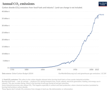
Global annual carbon dioxide emissions from 1750-2023. Credit: Our World in Data.
So when we see significant, so-called “termination shocks” caused by sudden reductions in aerosol pollution, as we have seen across the North Pacific region since 2013 – widespread, observable impacts to the climate system are likely.
These effects appear to be changing the typical expression of the PDO in the North Pacific, with more expansive and intense warmth amplifying the overall pattern (which may be shifting and strengthening mean atmospheric blocking). Indeed, it’s been found that human forcing (through greenhouse gas warming and reduction of air pollution) is causing a +PDO-like warming pattern in the North Pacific. At the same time, human forcing may reduce the PDO signal and shorten the duration of its phases – with some speculation that it could significantly reduce its predictability overall. All of this could influence Canadian wildfire seasons in unexpected ways.
The way forward
It is unknown to what extent the current pattern will continue in the future, and to what extent it is tied to the current -PDO sea surface temperature regime. How might things change when (or if) the PDO swings positive again, bringing warmer than normal sea surface temperatures along the west coast of North America? How might these changes influence atmospheric wind and pressure patterns above? Recent research suggests that marine heat waves in the northeast Pacific are more common during +PDO phases – but we’ve been seeing marine heat waves persisting in this region even though the PDO has been strongly negative. In any case, the persistence of the current climate regime and its widespread warmth across the North Pacific – along with its associated atmospheric wave train, are clearly contributing to worsened Canadian wildfire seasons since 2021.
Though the average summertime atmospheric wave train through much of the Northern Hemisphere seems to be forced primarily by the extreme warmth in the western and central North Pacific, it’s unknown to what extent that episodes of shallower warmth (associated with marine heat waves) in the eastern Pacific may also be forcing the jet stream. In any case, the entire North Pacific is rapidly warming, and a warmer ocean overall leads to warmer adjacent landmasses.
A warming climate increases the potential for wildfire spread in Canada by lengthening fire seasons, increasing the drying power of the atmosphere, increasing the risk of lightning at higher latitudes, and increasing the frequency and intensity of extreme heat and flash drought events. Combined, these play a major role in the amount of annual area burned, along with the severity of individual wildfire events like Lytton or Jasper. It is therefore no surprise that things have been unfolding as they have in recent years.
The way forward is complex. Many aspects of this discussion warrant much further research, and are emerging topics in climate and wildfire science. And while there is much uncertainty in how things could pan out in the near and distant future, it appears very likely that human influence is changing and amplifying natural climate variability in a way that makes drought and fire weather more likely across Canada. In the meantime, adaptation to the emerging reality of living with more fire is essential – even as we continue to work toward solutions to decelerate the warming of our climate.