Bird Migration on Weather Radar
Taking a look at 3 separate cases of bird migration as seen on weather radar in Alberta in May 2024, and discussing the science and weather behind it.
Weather radar is often used for detecting precipitation, but it can also reveal other non-meteorological objects in the atmosphere, including things like insects, dust, and birds.
This works as microwave energy is emitted from a rotating dish at the radar site that scans the atmosphere at different levels through 360 degrees, with an antenna that "listens" for echoes of backscattered energy that reflect off any objects it hits, giving us our radar imagery.
During the spring season, it can be quite exciting to use radar to track migrating birds. This May, there have been several examples of different kinds of birds making their seasonal trek northward up the central flyway of North America, through the province of Alberta.
Let's look at three examples.


Sandhill Cranes migrating over Edmonton, May 3
Flocks of Sandhill Cranes can be seen as linear segments of yellow and orange, moving from southeast to northwest over the Edmonton region on May 3. Radar indicates the bulk of the large birds were flying at an altitude of between 500 and 1000 metres above the ground.
The time of day that different birds migrate over land is often determined by their size. Large birds, such as cranes, geese, and birds of prey usually travel during the day, when they can utilize rising currents of air triggered by the sun or over topographical features, enabling their heavier bodies to stay in flight with less effort as they glide and soar along.
Here, we can see these birds migrating through the region during midday, where an ongoing, light northwest wind would have actually been acting as a headwind for the cranes. The birds could be seen tracking through the capital region on radar during the daytime from May 2nd through the 4th.
Nighttime migrants utilize strong tailwind over southern Alberta on May 4


Notice how the start of the radar loop above has a lot less pixels of colour, with an expanding area of blue and green "blooming" outward with time. Then, notice the time in the top right, which shows the radar loop elapsing between 9:23PM and 10:05PM MDT. On May 4th, the sun sets at about 9:04PM in Calgary, so what we are seeing is early development of the nocturnal inversion.
A temperature inversion is simply a profile where the temperature increases with height over some distance, before cooling with height once more. As the sun drops toward the horizon in the evening and eventually sets, the ground cools off more quickly than the air above. This causes the air near the ground to be cooler than a little ways up in the atmosphere, resulting in the nocturnal inversion.
The difference of air density in the vertical causes the microwave energy being emitted from the weather radar to refract back down toward the Earth, where it can impact the ground, causing radar returns called "ground clutter". The lowered radar beam can also pick up objects in the air immediately above the ground to scatter energy back to the radar, such as migrating birds.
It turns out that the night of May 4th was an excellent time for birds to migrate north over southern Alberta, as they were able to utilize a strong tailwind that developed a little after sunset.


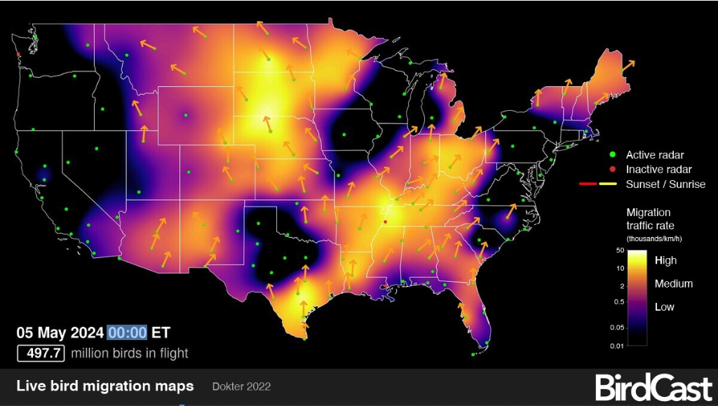
Based on Birdcast's live migration map, which unfortunately doesn't extend into Canada, we can extrapolate that the evening of May 4 into the early morning of May 5th was an active period for migrants traveling northwestward from the northern US plains states into the Canadian prairies.
Migrating birds utilize weather to their advantage, with research suggesting that warm temperatures, clear skies, favourable wind conditions, and rising atmospheric pressure could all play a role initiating northward migrations.
In contrast to our larger birds above, smaller birds that utilize "flapping" flight, such as songbirds, usually migrate at night. It is thought that this is because the atmosphere is more stable, with less gusty winds to buffet the birds about, along with cooler temperatures that could prevent overheating. It is even thought that the stars and moon may be used to help some birds navigate.
It is also worth mentioning here that it is good practice to turn out all lights during migration season, as the lights can disorient the birds at night, drawing them off course, and increasing the likelihood of window and building strikes that can (and does) kill birds.
Now, let's take a closer look at the weather conditions that supported a significant tail wind through the Calgary area overnight into May 5th.


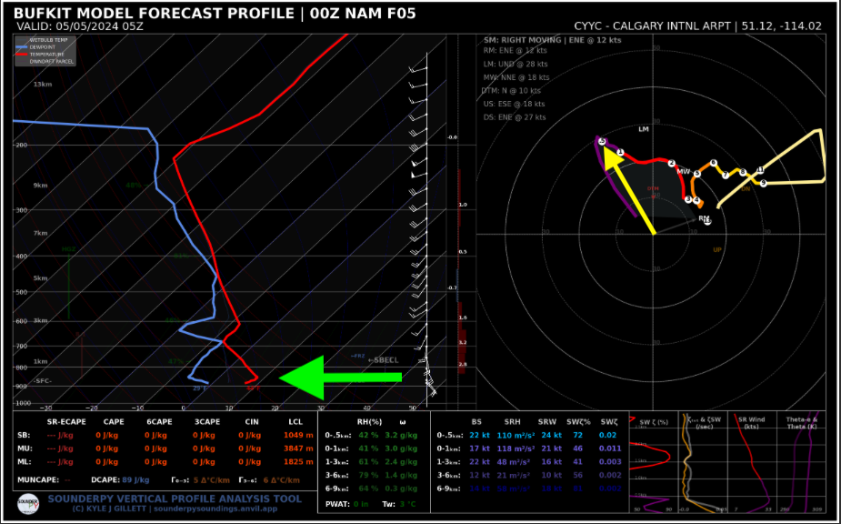
This graphic can be a little overwhelming, but it is basically just showing the forecast temperature profile (on the left) and the wind profile (on the right) with height through the atmosphere at Calgary Interational Airport, on May 4th at 11PM.
In the diagram on the left, notice the red line, which is temperature, and the blue line, which is the dewpoint temperature. Now notice the green arrow pointing at the kink in the bottom of the red line. This is the temperature inversion we spoke of earlier, which shows temperatures briefly increasing with height above the ground, before decreasing once again (there is also another inversion higher up).
During warm, sunny days, vigorous vertical air currents known as "thermals" can mix the lower atmosphere (when larger birds like to migrate), in a zone known as the planetary boundary layer. As wind blows over Earth's surface, friction causes the winds to be slower than they would otherwise be compared with the winds in the free atmosphere above the boundary layer.
As night falls, the cooling temperatures near the surface of the Earth cause the lower part of the boundary layer to decouple from the residual, upper part. Since the atmosphere likes to be in balance, it is now free to cause winds in the upper part of the boundary layer to speed up again, given the sudden lack of friction. However, the adjustment initially overshoots, and winds speed up significantly more than those in the cool air above the ground.
This results in a warm-season, nighttime phenomenon known as the nocturnal low level wind maximum. If migrating birds rise into this layer, which commonly exists a few hundred metres above the ground, they can get quite the ride northward in a tailwind.
Now, looking back up at the diagram on the right (a polar coordinate chart), notice the yellow arrow. This is basically showing a wind blowing from the southeast at about 30 knots (55km/h), at an altitude of 500 metres (notice the small ".5" in the purple segment of the line) at 11PM MDT, which is the footprint of that nocturnal low level jet.


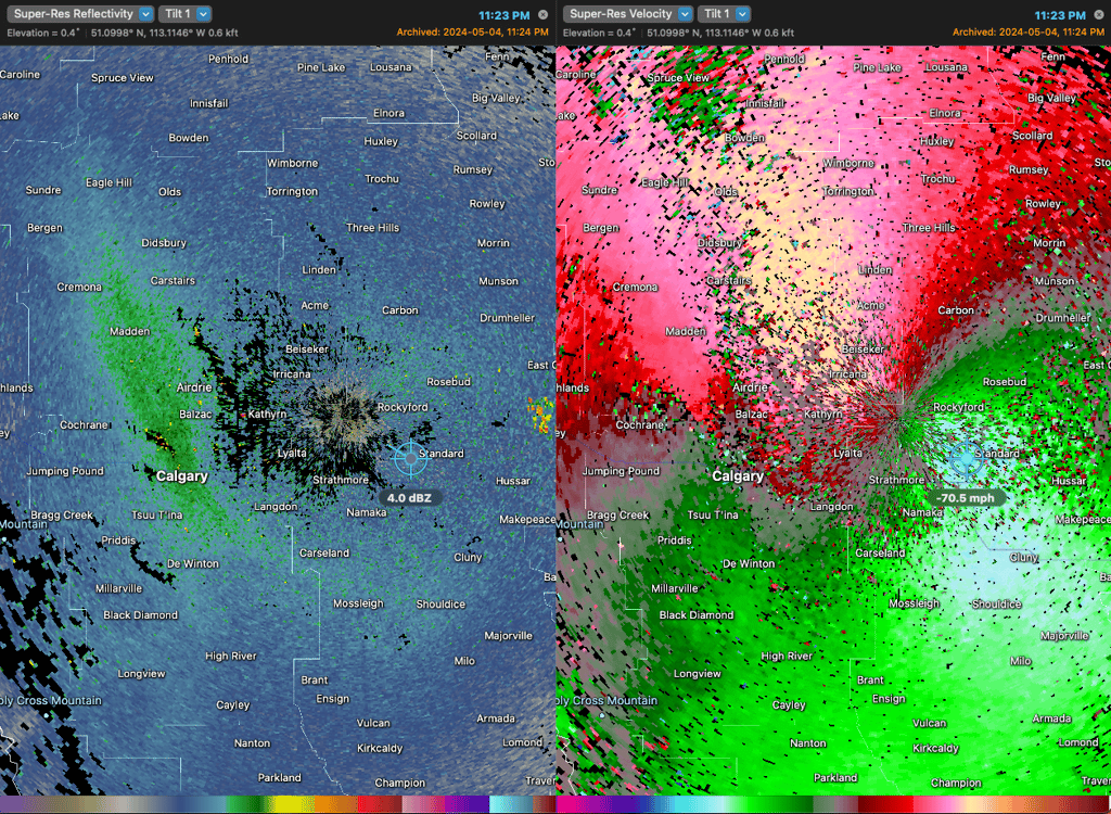
Here, we see a split radar image showing standard reflectivity on the left, with a product called velocity on the right. The latter simply utilizes the "doppler effect" to give us a sense of how objects are moving toward or away from the radar, with cool colours (green and blue) being motion toward the radar, and warm colours (red and pink) being motion away.
Analyzing the velocity data, we can see that the motion over the radar is from the southeast (with winds likely carrying the birds northwestward, also as indicated on the BirdCast image). Notice the "70.5 mph" indicator in the green on the right panel - this is indicating a velocity of 113 km/h at around 500 metres above the ground.
But wait! Didn't the forecast only show winds of about 55km/h at this level? This strongly suggests that there were birds migrating northwestward at a much higher velocity than the forecast winds, utilizing a tailwind as they went.


Birds "erupt" out of the Bow River valley on May 12
In our final example, notice the annotated arrow pointing to a sudden bloom of higher radar reflectivity (in green) just southeast of Calgary.
Nighttime migrants tend to initiate flight at about 30 to 45 minutes after sunset, which checks out here, given that the radar signature begins at about 9:59PM MDT, following the sunset at 9:17PM.


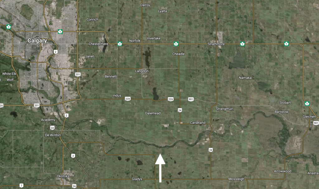
Notice the white arrow at the bottom of the image, pointing to the Bow River valley southeast of Calgary. Compare the shape of the river to the "eruption" seen on the radar. It seems a lot of those migrating songbirds were hanging out in the riparian vegetation, aspen, and cottonwood poplars in the river valley prior to departure.
I wonder what species would have been observed on May 12th. I'm sure there would have been some cool finds for birders!