2025 Canadian Prairie Tornado Outlook
For the storm chasers and weather weenies among us.
Kyle Brittain
5/17/20257 min read
Summer 2025 is drawing near, which means the Canadian Prairie convective season is about to ramp up. As we get into May, long range models continue to hold out on a hot and dry signal across most of western Canada this season. Could they be picking up on something?
Let’s dig into the nitty gritty.

What's happening now
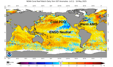
As of mid-May, sea surface temperatures are near normal in the central and eastern tropical Pacific, comprising the neutral phase of the El Niño-Southern Oscillation (ENSO). Further north, much of the North Pacific is warmer than normal, with a ring of cooler than average sea surface temperatures along much of the west coast of North America. This comprises the negative, or “cool” phase of the Pacific Decadal Oscillation (PDO). Finally, much of the North Atlantic remains warmer than normal, comprising the positive or "warm" phase of the Atlantic Multidecadal Oscillation (AMO). All three of these patterns are expected to persist into summer.

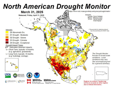
Meanwhile, there is patchy drought across parts of western Canada – albeit much improved compared with last year at this time. South of the border, drought is more widespread, with severe drought through much of the Southwest and into portions of the central and northern High Plains.
These spatial patterns of sea surface temperatures and drought are important because they can play a role in influencing the strength and shape of the summertime jet stream.
Atmospheric wave trains
The current and forecast warmth of North Pacific waters through the summer result in a gentler contrast in temperatures from south to north, which tends to cause a weaker jet stream aloft. Weaker jet streams tend to be wavier and can be more susceptible to “blocking patterns”, which are areas where the jet stream buckles and becomes stuck. This can lead to strong, persistent ridges of high pressure that bring prolonged hot and dry weather to areas below.
Since the late 1990s, the North Pacific has largely been in the cool phase of the PDO, which can make blocking ridges more common in western North America. The North Atlantic has also been in the warm phase of the AMO since about the mid-1990s. Combined, these patterns can lead to episodes of reduced summer rainfall from British Columbia through the Prairies. As it turns out, area burned has increased from wildfires in British Columbia during this time, while Prairie tornado numbers have overall decreased.
Sea surface temperature anomaly as of mid-May. Annotations mine. Credit: NOAA.
Spatial patterns of drought across North America as of the end of March. More recent updates are available for Canada and the United States on their respective agency websites - though the map looks similar as of the end of April. Credit: North American Drought Monitor.
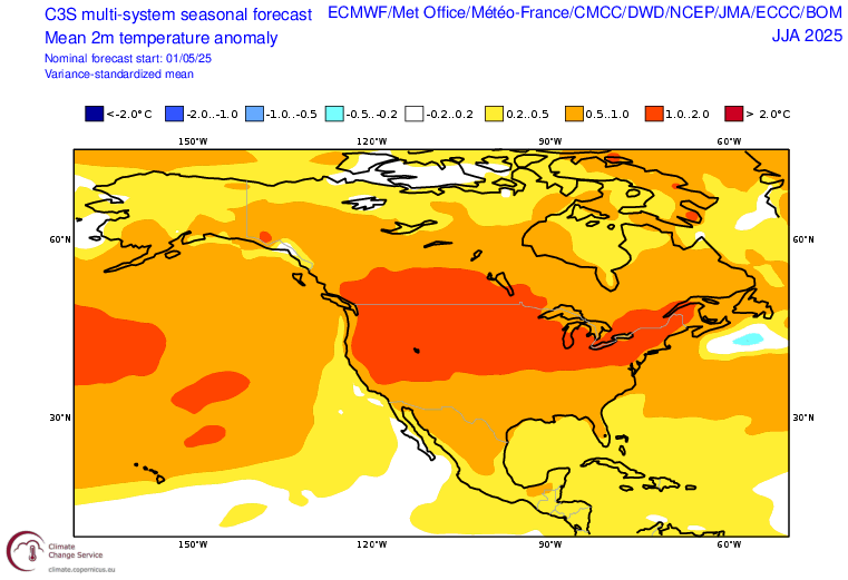
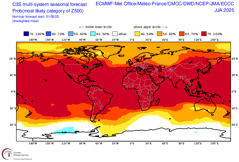
Long range model ensembles continue to favour above normal temperatures across much of North America during June, July, and August 2025. Credit: Copernicus Climate Service.
Thus, as these conditions persist through the summer of 2025, the odds would seem to be stacked in favour of yet another warmer and drier summer than normal, just as long range models show. Once again, this could mean elevated wildfire activity in British Columbia and the western United States, with reduced thunderstorm and tornado activity across the Canadian Prairies.
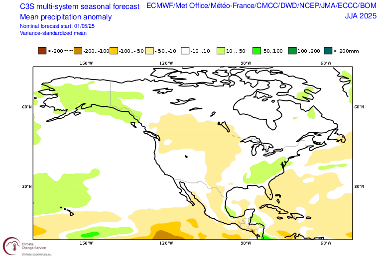
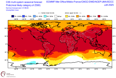
Long range model ensembles continue to favour drier than normal conditions across much of western Canada, and the central and northern United States during June, July, and August 2025. Keep in mind long range precipitation models have very little skill. Credit: Copernicus Climate Change Service.
It's not a slam dunk, though. Some summers see more regional variation, while others are cooler and wetter overall. It really comes down to the mean position of the jet stream during the summer, which can be forced by characteristics of the land and seas below.
Take 2012 and 2021 for instance. Compared with 2025, both years had some similarities in patterns of sea surface temperature and drought. 2012 was expected to be dry, but turned out wetter than normal from southern British Columbia to Saskatchewan. 2021, on the other hand, was extremely hot and dry, leading to severe drought across much of North America by the end of summer. So what gives?
Wetter, stormier summers in the Prairies tend to be favoured with mean troughing near or just off the BC coast, and persistent ridging further east over the heart of the continent. This brings an active, southwesterly jet stream with frequent disturbances across the Prairies that can support increased thunderstorm activity. In 2012, there was an area of anomalously warm sea surface temperatures between Alaska and Hawaii (near or just west of 160W), along with hot conditions in the interior of North America likely associated with widespread drought. This may have forced a wave train in the jet stream that favoured troughing off British Columbia.
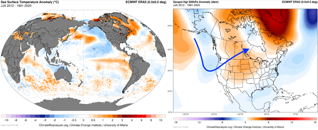
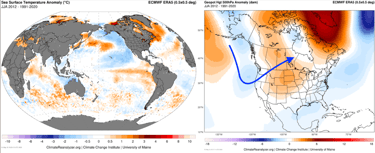
ERA5 Reanalyses of sea surface temperature anomaly at left, and 500mb height anomaly at right, for the period of June-July-August 2012. The upper height pattern is favourable for a mean southwesterly jet over the Prairies, which I have annotated with a blue arrow. This map may be better viewed on desktop. Credit: Climate Reanalyzer.
More commonly, however, a cold PDO results in a less active jet stream across the prairies as well as more west-focused ridging, as in 2021. That year, semi-permanent ridging set up over western Canada that greatly reduced rainfall and tornado activity, with a weakened, more poleward jet stream.
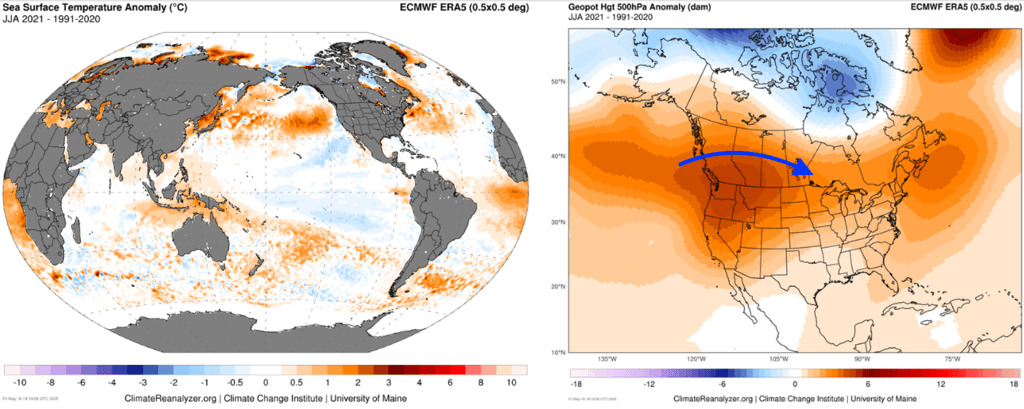
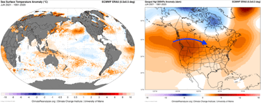
ERA5 Reanalyses of sea surface temperature anomaly at left, and 500mb height anomaly at right, for the period of June-July-August 2021. The upper height pattern results in a weaker, more poleward jet stream with mean ridging over western Canada, which I have annotated with a blue arrow. This map may be better viewed on desktop. Credit: Climate Reanalyzer.
What could happen next
For several months now, long range models have been advertising a hot, dry summer across much of western Canada this year. Given forecast sea surface temperature anomalies across the North Pacific, along with drought in the southwest and central United States that could contribute to greater sensible heat flux over west-central North America, it would seem possible that a wave train could set up that favours west-focused ridging over western Canada for much of the summer. This would lead to a less active jet stream, and more hot and dry weather that could cause drought to worsen, along with more wildfire activity that could cause smoke that further stifles thunderstorm activity.
Forecast 500mb height anomaly for June, July, and August 2025. Note the five wave crests across the Northern Hemisphere. Credit: Copernicus Climate Change Service.
Also interesting are forecasts for five main wave crests in the jet stream throughout the Northern Hemisphere this summer. This wavenumber five pattern can cause the jet stream to preferentially phase with Northern Hemisphere geography, causing persistent, simultaneous ridging in the world’s major breadbasket regions. This could lead to prolonged heat waves and drought in the interior of North America, at the same time as eastern Europe and parts of East Asia.
What ultimately pans out may also depend on what happens in the next few weeks. Already, we are seeing a much wetter signal in the northern Plains of the United States and parts of the Canadian Prairies than long range forecasts have been indicating. This could lead to regional reductions in drought and ridging strength, while perhaps triggering the moisture recycling process. If things trend wetter still across much the west into June, summer could go either way.
What this could mean for tornado season 2025

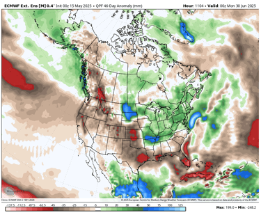
ECMWF 46-day precipitation anomaly forecast for between mid-May and the end of June. Notice the wet anomaly in the Northern Plains, which will likely provide some drought relief - at least temporarily. Credit: Weatherbell.
Even if things trend wetter for parts of the Prairies this summer, that’s not a guarantee we’ll see increased thunderstorm and tornado activity. Active thunderstorm seasons require both moisture and an active jet stream pattern, with frequent troughs migrating across the region. Under the current climate regime, tornadoes overall have been less frequent across the Prairies – even during wetter years. Therefore, it’s not unreasonable to expect that this trend could continue into this summer.
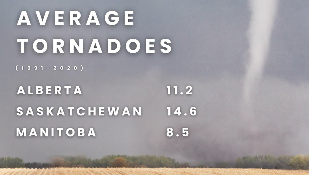
For instance, this year we have transitioned from a weak La Niña into ENSO neutral conditions, with the background cold PDO and warm AMO. Since the turn of the century, every other time we have transitioned from weak or moderate La Niña conditions to neutral in the summer, amid the background cold PDO and warm AMO – save for 2012 – we have seen below average tornado activity across the Prairies. This includes 2001, 2009, 2018, and 2021. In all of these years, Alberta and Manitoba have seen below to well-below normal tornado activity. Saskatchewan can be the wild card, with 2012 and 2018 being the only two of those five years with above normal tornado activity.